Year:
Client:
Category: Telecom Line Classification
Location:
Here To know about this project
Project Title
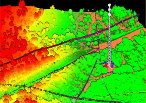
Telecom Line LiDAR Mapping & Classification
Project Overview
We deliver high-precision Telecom Line LiDAR Mapping and Classification services to support network planning, asset management, and corridor monitoring. Using advanced LiDAR point cloud processing techniques, we accurately identify and classify telecom infrastructure and surrounding features even in dense vegetation and complex terrains.
Scope of Work
-
Telecom line extraction and classification
-
Tower and pole identification
-
Vegetation encroachment analysis
-
Terrain and corridor modeling
Key LiDAR Classifications
-
Telecom Lines
-
Transmission / Support Poles
-
Vegetation (Low, Medium, High)
-
Ground & Terrain
-
Access Roads & Pathways
-
Surrounding Structures
Technology & Tools Used
-
UAV / Aerial LiDAR Point Clouds
-
TerraSolid (TerraScan, TerraModeler)
-
MicroStation & AutoCAD
-
ArcGIS / GIS-based Analysis
Deliverables
-
Classified LiDAR Point Cloud (LAS/LAZ)
-
Telecom Line 3D Models
-
Vegetation Clearance Reports
-
Corridor & Risk Assessment Maps
-
GIS-ready datasets and CAD outputs
Project Benefits
-
Improved telecom network planning
-
Accurate vegetation risk identification
-
Reduced field survey time and cost
-
Enhanced asset visibility in 3D space
Industry Applications
-
Telecom Network Expansion
-
Fiber & Wireless Infrastructure Planning
-
Maintenance & Safety Analysis
-
Smart City and Digital Connectivity Projects
Need Help? Call Here