Year:
Client:
Category: Power-Line Classification
Location:
Here To know about this project
Project Title
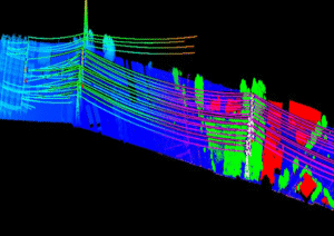
Advanced Power Line LiDAR Mapping & Utility Corridor Classification
Project Overview
We delivered a high-precision Power Line LiDAR Mapping solution designed to accurately identify, classify, and model transmission and distribution infrastructure within complex environments. Using advanced point cloud classification techniques, the project supports safe utility planning, asset management, and corridor monitoring.
Scope of Work
Our team processed high-density LiDAR point cloud data to extract and classify critical power line components while maintaining spatial accuracy and engineering standards.
Key Deliverables
-
Power Line Extraction – Accurate identification of conductors across varying spans
-
Transmission Towers & Poles – Precise classification of utility structures
-
Vegetation Classification – Detection of trees and encroachments near power lines
-
Ground & Terrain Modeling – Reliable DTM for elevation reference
-
Utility Corridor Mapping – Clear visualization of right-of-way and safety zones
Technology & Tools Used
-
Airborne / UAV LiDAR Data Processing
-
Advanced Point Cloud Classification Workflows
-
MicroStation, TerraSolid, Global Mapper, ArcGIS
-
Industry-standard QA/QC Procedures
Project Highlights
-
High-accuracy classification even in dense vegetation areas
-
Clear separation of conductors, poles, towers, and surroundings
-
Optimized outputs for utility maintenance and risk assessment
-
Scalable solution for long transmission corridors
Business Value
This solution enables utility companies to improve network reliability, reduce outage risks, and plan maintenance proactively by providing a clear, data-driven view of power line infrastructure.
Need Help? Call Here